-40%
USGS GEOLOGY, OIL & GAS in the ELK HILLS, With MAP! KERN COUNTY CALIFORNIA1932
$ 7.39
- Description
- Size Guide
Description
SCARCE VINTAGE ITEM WITH GREAT MAP!This is USGS Bulletin 835,
Geology and
Oil Resources of the Elk Hills, California.
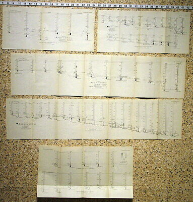
Published in 1932, there can’t be many of these around anymore. This publication consists of the 82-page book and, amazingly all of the original maps! There are five folded maps bound in the book, several plates of air photos of the area, a plate of fossil shells from the formation, and pocket that contains a large color map of the area and five charts correlating the geology across drill holes.
The Elk Hills are in western Kern county and produced oil from formations near the Temblor Mountains. The Elk Hills themselves form a range of low hills of their own, comprising an area of about 6x17 miles. The surface rocks are fairly young Pliocene and Pleistocene units of the Tulare formation.
The book discusses the history fo discovery of oil in the are, the geology in detail, some production numbers and many other aspects, But the real prize here is the map. It is about 35 by 18 inches an shows the topography and a bunch of other features of the area. Many of the oil wells are shown, forming grids of holes used to tap all the productive parts of the formations. It has a cool vintage look to it and would look great framed and hung in a home or business in the area.
This is a cool old report that is pretty easy to read. Reports from this era tended to be less technical. The map is fantastic and the whole things is packed with cool stuff. This is the only one I have ever had, and these reports from Pre-World War Two are harder to find then younger ones. Get it will it lasts
As always please read the condition notes.
Expert packing assured. Shipping weight is one pound. The recent increase in postage rates was pretty big. As a result, Media Mail is now my default shipping method to keep shipping affordable.
Visit my store,
Rockwiler Books and Minerals.
I will continue to add items to my store, so check back frequently.
®
ROCKWILER


